As you walk shoulder-to-shoulder among the crowd, stop for a moment to take a look into the distance from the overhead bridge on Chunghwa Rd. You'll notice that the Chunghwa Marketplace resembles the Great Wall as if it is defending Hsimenting. Here you'll find the incessant flow of people and traffic. Taking a look back at the rotary, where you can see the beginning of what people refer to as "Movie St." and "Clothing St.," a never-ending flow of people moves along. As night falls, the flashing of neon lights turns this place into Taipei's most sparkling diamond.
Some say that prosperity is like a dream, and that the world changes quickly, but this kind of feeling isn't so with Hsimenting.
Stand still on the overhead bridge for a minute. If the hands of time could be turned back one hundred years, you'd find yourself on the western side of the wall which once surrounded Taipei looking off into the distance. Back then, Hsimenting's name was not "Flourishing."
One hundred years ago, Taipei was surrounded by a sturdy protective wall. The wall, completed in three years, was square, and had four gates, one in the north, south, east, and west. There was also another small gate on the southern side. The stairs to the side of the various gates led to the second story and to the top of the wall.
During the day, except for some women washing clothes, farmers cultivating land, shepherd boys grazing cattle, and lumberjacks cutting wood, there would occasionally be a few folks with some extra time on their hands who would lay on a small mound and hum a melody. Besides these, there are very few traces of man.
As the sunset in the west and night began to fall, the city gates would be closed. Here, only the sounds of crows and the hum of insects remained. The atmosphere was very ominous, which provided the people within the city with great material for talks of strange events as they chatted in the teahouses after dinner.
Times have changed since then. Now, "Let's go to Hsimenting!" has become a recurrent phrase. It may mean, "Let's go see a movie!" or "How about going shopping?" Regardless of whether one means "see a movie" or "go shopping," both the speaker and listener understand that it means to head towards that people-packed, bustling place.
Just exactly where is Hsimenting? Everyone seems to be sure. Naturally, you won't find the name of this place, where east meets west, on a map. Does Hsimenting actually have any clear-cut boundaries?
If you take a look at a map of Taipei during the Japanese Occupation, you'll discover that at that time Hsimenting was limited to today's Chunghwa Rd. to Kangting Rd. and the both sides of Chengtu Rd. Most people understood Hsimenting to mean the bustling shopping area filled with all sorts of stores. The range of Hsimenting included the former Suehiro-cho, Kotobuki-cho, Hama-cho, Izumi-cho, and Tsukiji-cho. These five districts were grouped by the Japanese as a Hsimen Association. Now, this city block is considered to include Chunghwa Rd. to the north, Kunming St. to the west, the beginning of Hankou St., and south as far as Chengtu Rd.
The broad, level sidewalks and the newly constructed houses have attracted a large number of the population to move to the area. On account of this, Hsimenting has begun to thrive at a rapid pace.
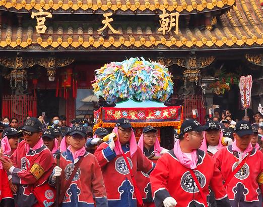
Perhaps you've had the following experience: You're walking through Hsimenting, among the throngs of people, when suddenly, sandwiched between a row of shops you stumble upon two stone images. You take a look inside only to discover that, in this mundane world, there's a Matsu Temple where incense is burning.
This is Tien Hou Kung, which is also the only remaining temple in the area. During the Japanese Occupation, the Japanese continued to build many Japanese temples and Shinto shrines. Higashi Honganji and the Shinshu--Nishi Honganji were two large temples in the area. These two temples were the center of Buddhism for the Japanese people while on Taiwan. The locals called them Ho Shang Chien, meaning "Monks' Place."
The flashing neon lights resemble the style of the sixties and seventies; young people sit in the coffee shops and talk about post-modern deconstruction. Once a famous star committed suicide by jumping from the overhead bridge onto the train tracks below. Young gals are engulfed in their own dream of being a star. Some people are getting rich while others are losing their shirt.
The dream of the Taipei people ends and begins again in this same spot, and, like a movie, is played over and over. Is it any wonder that Hsimenting's graceful appearance is aging?
[Picture Caption]
The West Gate of Taipei City is also called Pao Ch'eng Gate.
Seen is an old map of Mengchia (Wanhua) drawn back in 1895. The wall is located at the right of the map; Tamsui River in the upper left hand corner; the blank space in the center is Hsi-menting.
This photo of the rotary by the West Gate was taken in 1935. After forty years of construction, Hsi-menting is no longer the marshland it once was.
Hengyang Rd. (Taipei) during the Ching Dynasty. In 1885, under the order of Governor Liu Ming-ch'uan, roads of rock slabs and gravel were built. On both sides of the road two-storied storefront dwellings were built. The memorial archway seen here has been moved to Taipei New Park. Seen in the distance is the West Gate of the city.
In 1911, residents along Hengyang Rd. lost almost everything in a flood. Street scenes changed dramatically as European-style buildings were built during the Japanese Occupation. In 1922 the name of this road was changed to Sakae-cho.
Poai Rd. was called Kyo-machi during the Japanese Occupation. It was also the sight of Renaissance-style buildings, and, like Hengyang Rd., was a major gathering spot of stores.
This strip in the city has always been an administrative and financial center of Taipei.
The Higashi Honganji Temple is fashioned after Tang Dynasty architecture. The main area of the temple is 5O0 ping. The two porticos and the surrounding garden measure about it the largest Buddhist temple in Hsimenting. Unfortunately, it was destroyed in 1975. Now, illegal buildings occupy the sight.
The Hsimenting door as seen a long time ago. The Hsimen Marketplace was also known as Hunglou meaning "red building." The Hsimen Marketplace was made of red bricks and was octagonal.
The Shihshu--Nishi Hon-ganji is fashioned after Indian style. It has since been torn down to make room for the Lailai Department Store and Lion's Commercial Building.
The Hsimen rotary during the fifties and sixties. The area around the fountain, under the giant neon lights, has become both a resting and meeting place.
The Tien Hou Kung, located on Chengtu Rd., is the sight of the former Hung Fa temple. It's very active with many people burning incense. (photo by Arthur Cheng)

Seen is an old map of Mengchia (Wanhua) drawn back in 1895. The wall is located at the right of the map; Tamsui River in the upper left hand corner; the blank space in the center is Hsi-menting.

This photo of the rotary by the West Gate was taken in 1935. After forty years of construction, Hsi-menting is no longer the marshland it once was.

Hengyang Rd. (Taipei) during the Ching Dynasty. In 1885, under the order of Governor Liu Ming-ch'uan, roads of rock slabs and gravel were built. On both sides of the road two-storied storefront dwellings were built. The memorial archway seen here has been moved to Taipei New Park. Seen in the distance is the West Gate of the city.

In 1911, residents along Hengyang Rd. lost almost everything in a flood. Street scenes changed dramatically as European-style buildings were built during the Japanese Occupation. In 1922 the name of this road was changed to Sakae-cho.

Poai Rd. was called Kyo-machi during the Japanese Occupation. It was also the sight of Renaissance-style buildings, and, like Hengyang Rd., was a major gathering spot of stores.

This strip in the city has always been an administrative and financial center of Taipei.

The Higashi Honganji Temple is fashioned after Tang Dynasty architecture. The main area of the temple is 5O0 ping. The two porticos and the surrounding garden measure about it the largest Buddhist temple in Hsimenting. Unfortunately, it was destroyed in 1975. Now, illegal buildings occupy the sight.

The Hsimenting door as seen a long time ago. The Hsimen Marketplace was also known as Hunglou meaning "red building." The Hsimen Marketplace was made of red bricks and was octagonal.

The Shihshu--Nishi Hon-ganji is fashioned after Indian style. It has since been torn down to make room for the Lailai Department Store and Lion's Commercial Building.

The Hsimen rotary during the fifties and sixties. The area around the fountain, under the giant neon lights, has become both a resting and meeting place.

The Tien Hou Kung, located on Chengtu Rd., is the sight of the former Hung Fa temple. It's very active with many people burning incense. (photo by Arthur Cheng)

@List.jpg?w=522&h=410&mode=crop&format=webp&quality=80)
@List.jpg?w=522&h=410&mode=crop&format=webp&quality=80)