Construction of the Central Cross-Island Highway began on July 7 1956. The 277 kilometers of road was finally ready on April 29, 1960, after nearly four years of backbreaking labor, and it opened to traffic on May 9 of the same year.
The provincial highway authority had been planning a link through the mountains since 1950, and had surveyed the route, but the project had been shelved due to the enormity of the task and lack of funds.
It wasn't until 1954 that Chiang Ching-kuo, then chairman of the Vocational Assistance Commission for Retired Servicemen, re-initiated the project in order to connect the two sides of the island and provide employment for ex-army personnel.
Seven types of labor
It took ten years for the whole project to be realized, from surveying through to planning and construction. During the construction phase, an average of 5,000-6,000 people were working on the road on any one day. This gives some idea of the scale of the project. For organizational purposes the workforce was divided into seven categories: veterans' engineering corps, infantrymen, military convicts, job training brigades, unemployed youth, public and privately owned enterprises, and, in summer, student volunteers from the China Youth Corps.
The difficulty of the task was compounded by a series of typhoons and earthquakes which struck Taiwan during the road's construction. At 4 a.m. on February 24, 1957, the Hualien region was rocked by a powerful quake which brought boulders tumbling onto the Taroko-Hsipan stretch of the road, knocking down bridge supports and destroying work huts. There were more than 20 casualties and progress on the project was seriously affected. In 1959 a pair of strong typhoons caused NT$10 million worth of damage, triggering landslides over some 200,000 square meters of mountainside and wrecking communications equipment along the length of the highway.
The fragile, precipitous terrain through which the highway cuts, combined with the succession of typhoons and earthquakes, made for extremely difficult construction conditions. Also, inaccessibility of the route to mechanical digging equipment meant that most of the work was done by pick and shovel. The fact that the highway was hacked out of the hills by hand further added to its international renown.
Stunning scenery
While the highway was being pushed through the mountains, Chiang Ching-kuo penned an essay entitled "Spending the Night in a Place With No Name," in which he described an evening among convicts working on the road and depicted the hardships of the project.
The complete cross-island link consists of three sections: the main highway, a 194.2 kilometer route from Tungshih in the west to the Suao-Hualien Highway on the east coast; a branch running north from Lishan to Ilan; and a spur road from Wushe.
In addition to dramatically shortening the gap between Taiwan's west and east coasts, the road brought the vertiginous grandeur of Taroko Gorge within reach of visitors from around the world. Indeed, the highway is lined with stunning scenery for much of its route. The buildings which are today known as the Tienhsiang Activities Center and the Lishan Guesthouse were originally medical centers for the road crews, and in the grounds of Tienhsiang's Changchun Temple there is a memorial to those who perished during the course of the work.
Recalling bygone days
Taroko National Park Administration is this year holding a series of special activities to mark the 40th anniversary of this scenic highway that doubles as a transportation link and a tourist attraction, and draws a million visits every year. The events are designed to recall the efforts of those who built the road, giving participants a sense of what the mountains are like and helping them to learn about the highway. Events include the Taroko Gorge International Marathon, hikes along the Old Hohuan Trail, river ecology activities, a geology study camp, and an exhibition of historical photographs. The photo exhibition includes pictures of the original trail from the Japanese colonial period, and of the surveying and construction work for the highway. The pictures showing locations along the highway then and now, and the video documentary about the road, are an eloquent testimony to its 40-year history, and help us to gain some sense of the hardships involved in its development.
p.80
The Taroko Gorge was voted one of the eight scenic wonders of Japanese-ruled Taiwan. The suspension bridge, tunnel and monument were familiar features of the gorge entrance. (courtesy of Lee Jui-tsung)
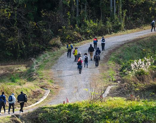
Forty years on, the mountain scenery of the Pilu Cliff section of the Old Hohuan Trail is as beautiful as ever, but the trail itself is now deserted. (courtesy of Lee Jui-tsung)
p.81
The entrance to the Taroko Gorge, at the opening of the Cross-Island Highway in 1960. The elaborate ceremonial arch, erected to commemorate the occasion, has become a major landmark.
p.82
Along much of its route, the Central Cross-Island Highway passes through geologically unstable areas with many sheer cliffs. This made its construction a daunting engineering task. (courtesy of Taroko National Park Headquarters)
Because the fragile geology made it impractical to use heavy machinery, much of the highway was cut through laboriously by hand. (courtesy of Taroko National Park Headquarters)
The Central Cross-Island Highway winds its way between lofty mountain peaks and ridges. The workmen building the road often had to run makeshift stairways across sheer cliff faces to access the work areas. (courtesy of Taroko National Park Headquarters)
p.83
Above the Cross-Island Highway, the Chuilu Cliff section of the Old Hohuan Trail can still be seen winding through the forest. The sight of the trail and the highway sometimes running in parallel, sometimes crossing each other, expresses the contrasting moods of two very different ways of traveling.
At Swallows Grotto, one of the famous scenic spots along the highway, one can see from close up the historic marks left behind by the road builders' chisels.
@List.jpg?w=522&h=410&mode=crop&format=webp&quality=80)